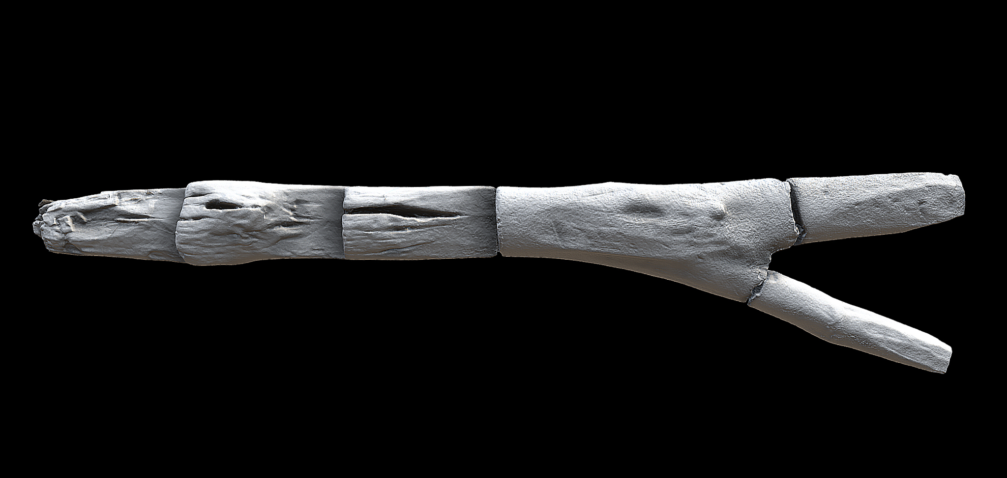
Ladders such as these, with notched steps down one face, are the most commonly known type of ladder used to access later prehistoric field wells and waterholes in England.
Archaeological investigations at Bucklers Park in Crowthorne, Berkshire, have revealed a window onto a significant later prehistoric place, which was used and revisited over 1700 years between the Early Bronze Age and later Iron Age. A series of wells, burnt mounds and troughs indicate that activity at the site was focussed around the heating of water using hot stone technology
The ladder was found in a well, one of a series that were dug from the early Middle Bronze Age onwards. These wells are associated with a series of burnt mounds, a puzzling site type the remains poorly understood.
Burnt mounds are mounds of fire-cracked stone, often associated with the heating of water using hot stones. Stones are heated in a fire and then placed into troughs filled with water. The rapid change in temperature causes the stones to break into pieces which are scooped out and set aside, eventually forming a mound.
These troughs might be filled with water from a nearby stream, or from water drawn from under the ground via a well.
The function of burnt mounds remains uncertain. Existing interpretations include food processing or cooking, brewing, bathing, the creation of steam for sweat lodges or saunas, textile production, the working of wood and leather, and even copper production. It’s also entirely possible that not all burnt mounds served the same purpose.
At Bucklers Park, the bathing hypothesis is one possible interpretation, supported by the presence of a human flea, which we might expect to find in areas associated with washing or grooming. However, the flea was associated with domestic waste that had been dumped into the well, so it may have entered the well this way rather than during bathing activities.
Work at Buckers Park was undertaken by AOC Archaeology Group, who were commissioned by RPS on behalf of Legal & General Homes.
Access All Areas
The well in which the ladder was found was up to 5m in diameter and 2.6m deep, with the sides being almost vertical except at the northern edge which formed a gentle slope. Leaning against this slope was a large, notched ladder made of birch. The ladder was radiocarbon dated to 12th-13th century BC, placing it firmly within the Bronze Age. It is associated with the well’s final phase of use.
The ladder most likely served to give access to the well, allowing people to climb down into it to collect water.
A Special Deposit?
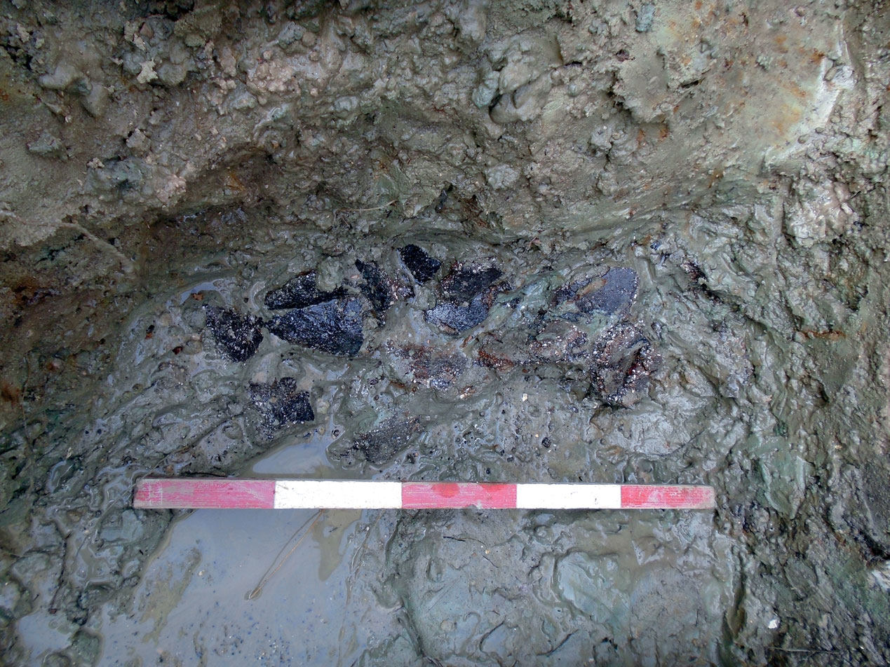
One of the other wells at the site was found to contain around 100 sherds of pottery from the same vessel, an urn. While the vessel may have been dropped accidentally into the well, it seems more likely that it was deposited intentionally as a special offering of some kind.
Crowthorne ladder sections
Crawthorn ladder druring excavations, with section drwaing
Crawthorne ladder - 3D render
Sherds of pottery discovered on site.
explore the 3D model⚬
explore the 3D model⚬
explore the 3D model⚬
explore the 3D model⚬
explore the 3D model⚬
‘Hot Stone Technology at Bucklers Park, Crowthorne, Berkshire: The Use and Re-use of a Persistent Place During the Bronze and Iron Ages’ is available through the Proceedings of the Prehistoric Society
Authors: Helen Chittock (AOC), Robert Masefield (RPS Consulting), Enid ALlison (Canterbury Archaeological Trust), Anne Crone (AOC), Derek Hamilton (SUERC), Suzi Richer (Richer Environmental), Jackaline Robertson (AOC) and Alex Wood (AOC).
A photography-based 3D recording method using 2D images to extract 3D information. This is done by reading perspective variations and differences in lines of sight in multiple overlapping images.
Its adaptability, scalability and potential to create highly accurate 3D outputs, regardless of the size of the subject recorded, made photogrammetry a widely popular 3D recording technique.
Used in the heritage sector in a broad spectrum of applications: from creating a detailed record of archaeological sites and buildings to conservation monitoring and long-term preservation of fragile museum collections.
Laser Scanning
Terrestrial laser scanning is one of the primary techniques that enable the rapid and highly-accurate acquisition of 3D data.
The scanners measure the 3D geometry by sending a laser beam to the surface of the recorded structure. The beam hits the surface and returns to the scanner – based on those two events the scanners can calculate distances and angles, assigning each measured point a precise location in 3D space.
Capturing millions of measurements per second, laser scanning became one of the primary tools used in surveying due to its speed and ability to produce high-resolution data. Laser scanned point clouds can provide valuable metric data, giving cross sections through buildings, or accurate terrain models of slight topographic features. 3D data can be processed into highly accurate CAD models for visualisation, or used to extract detailed 2D elevations and plans.
Reflectance Transformation Imaging (RTI)
Reflectance Transformation Imaging ( RTI) balances between 2D and 3D imaging. Whilst it captures 2D images, it allows for the object recorded to be digitally re-lit, creating an illusion of 3D surface. RTI dataset is created by capturing a series of images from a fixed camera position with the artefact illuminated by a light source incrementally moved around on a hemispherical grid. It records the subject’s shape and colour and is particularly useful for enhancing fine surface detail invisible under regular illumination.
3D printing
Archaeological artefacts can provide a tangible link to people who lived centuries, or even millennia, before us. However, most are too fragile to be handled freely and are viewed behind glass or stored in archives. 3D prints of artefacts, made from highly accurate 3D models created from data gathered through digital recording methods, can provide an opportunity for a tactile experience, allowing a more personal connection. 3D printing technology is also making heritage more inclusive and accessible for people with visual impairments – dedicated handling kits are gaining more popularity across cultural institutions in the UK and beyond.
3D Reconstructions
Digital reconstructions allow us to visualise lost archaeological sites or piece together fragmented artefacts recovered during excavations. Particularly useful in the analysis and interpretation of fragile archaeological finds, 3D reconstructions allow specialists to examine objects in a non-invasive way and experiment with innovative methods of communicating the results of these analyses.
Based on photos, archival maps, LiDAR data or 3D scans, digital models of cultural assets can be created and experienced in the virtual world by the viewer. Those reconstructions provide a way for audiences to explore artefacts from afar and present a fascinating new opportunity for engagement with the past.
LIDAR analysis
LiDAR (Light Detection and Ranging) is a remote sensing technique, used for high-resolution survey of landscapes.
The technology is based on the use of a laser scanner, mounted on an aircraft. Laser scanners emit pulses of laser light at a rate of many hundreds of pulses per second,
and measure the time it takes for the reflection of that pulse to return to the instrument; a GPS is used to plot the coordinates of each measurement. Using this method, computers are able to process millions of measurements in a dataset called a ‘point cloud’. In turn, this point cloud is then used to make very detailed presentations of the ground surface, called ‘digital terrain models’, often referred to as ‘DTMs’.
UAV Survey
Drones in the heritage sector are used as a low-level aerial method of recording archaeological sites, historic buildings, tall monuments, and landscapes. Equipped with high-resolution cameras, drones can access high-level structures to facilitate the inspection of historic sites. Accurate 3D records are generated from gathered images and used for survey, conservation, and maintenance work.
360⁰ Virtual Tours
Immersive way of making remote heritage sites more accessible. By taking a series of 360⁰ images, or spherical panoramas, we can create virtual tours of archaeological sites and historic buildings.


