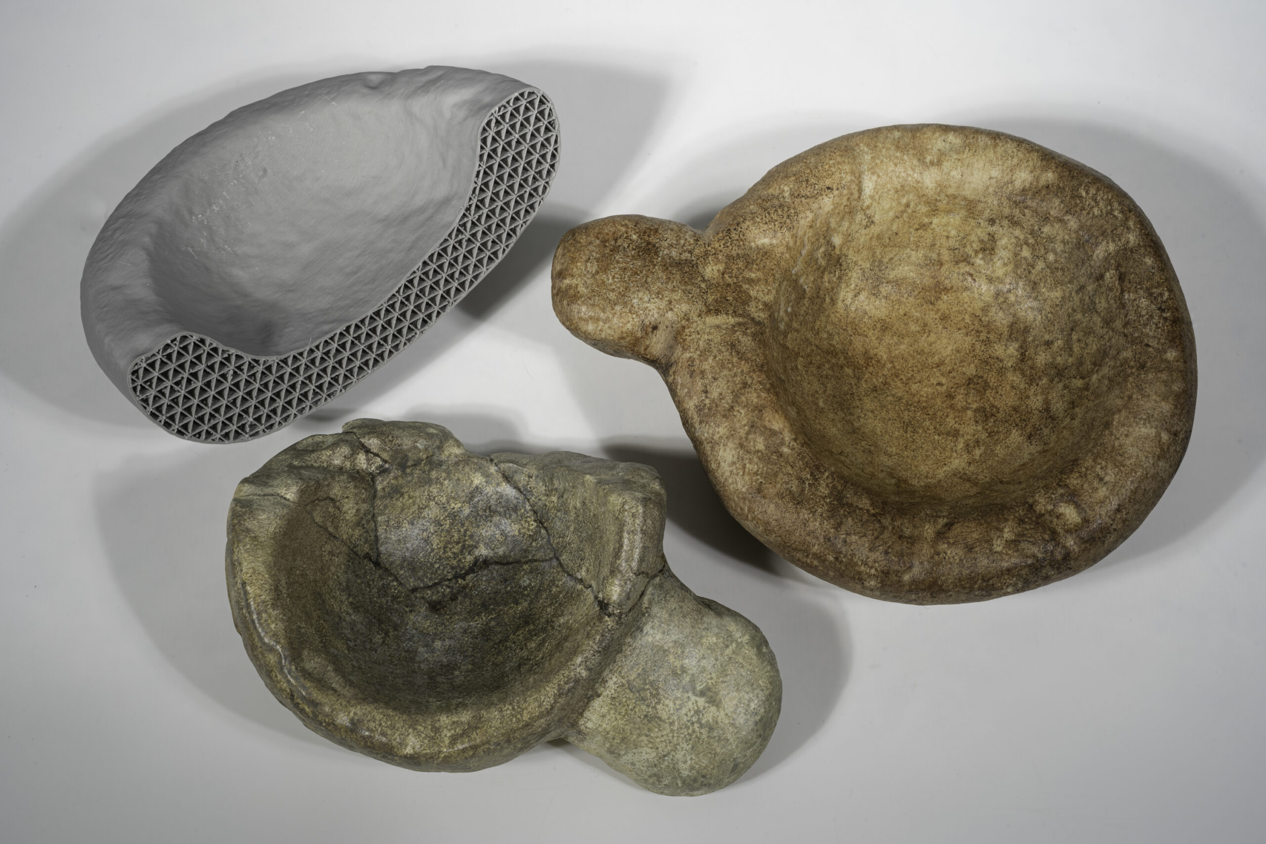
A selection of objects was replicated using 3D printing technology so that they can be housed in a ranger hut close to the broch. Made of polymer composites, they are durable and can be exhibited without the need for climate-controlled conditions.
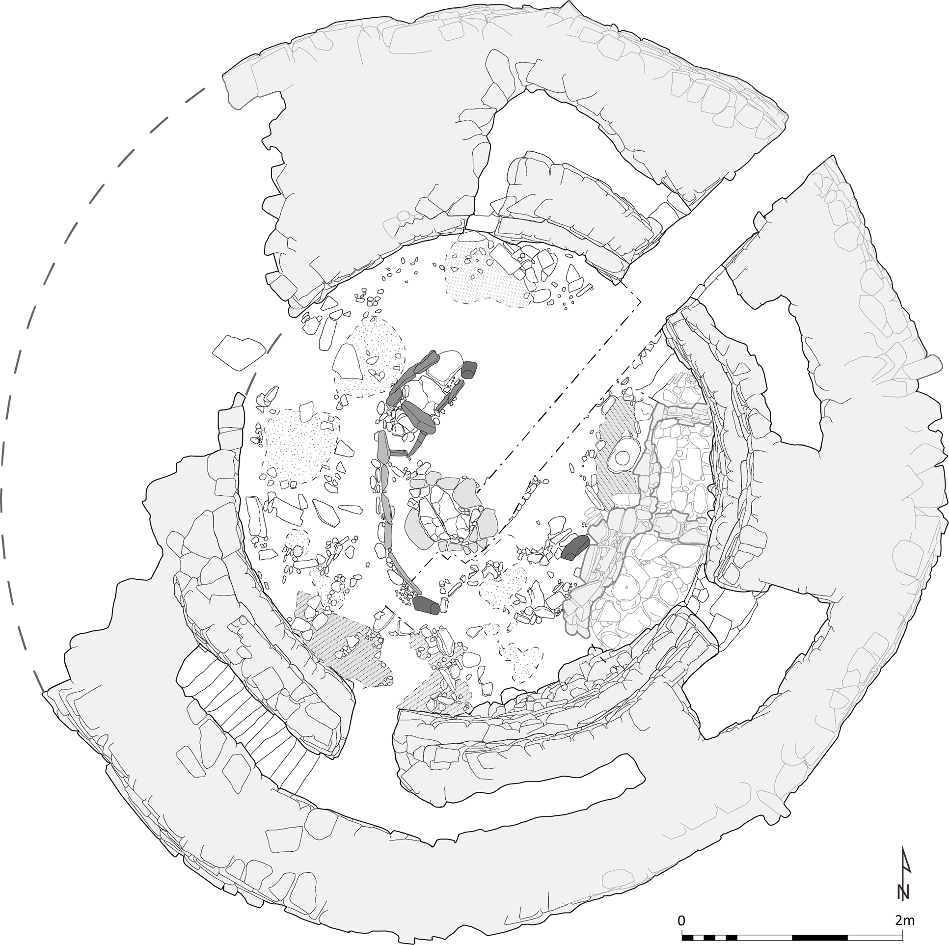
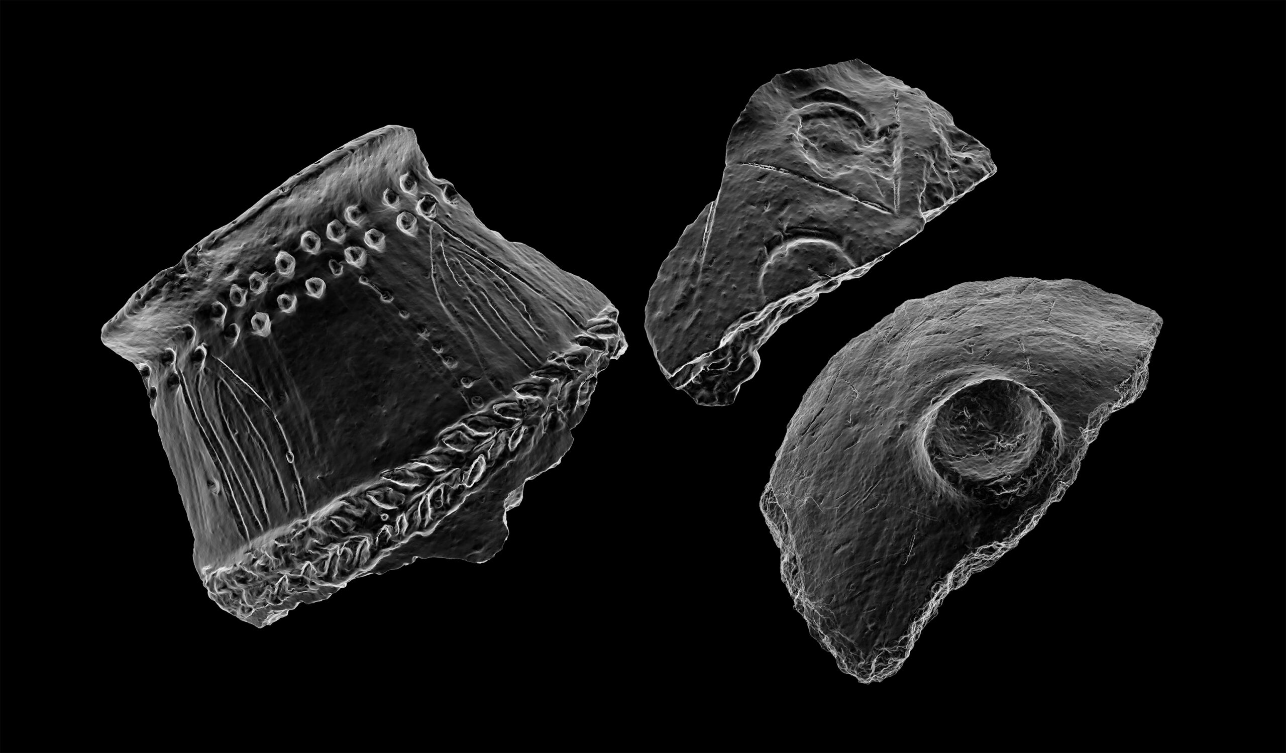
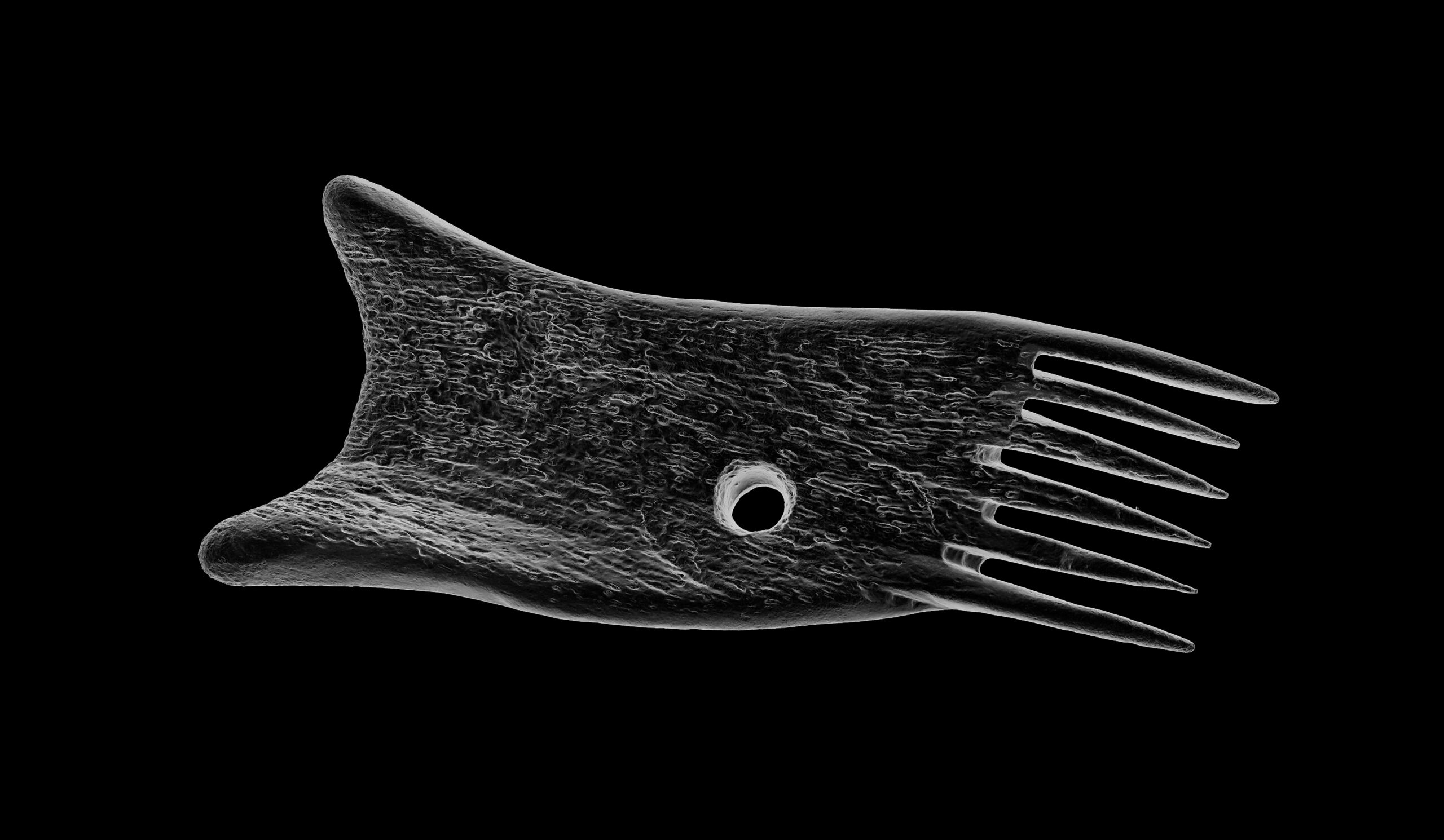
Many years of work by Historic Assynt to consolidate and conserve Clachtoll Broch led to full excavation of the site in 2017 with hundreds of artefacts retrieved during the work. The excavation at Clachtoll provided a snapshot of life in Assynt in the Iron Age.
The construction of a new ranger hut at Clachtoll Beach car park presented an opportunity to provide new information about the broch for visitors: information panels would tell the story of the broch and an exhibition window would house the excavated artefacts. The exhibition window, however, would not be climate controlled.
This meant it would not be appropriate for genuine artefacts, which would deteriorate in an environment of ever-changing light, heat and humidity. 3D printed replicas provided a solution. They look identical to the originals, but aren’t at risk of deterioration – and even if they were to deteriorate, they could be replicated again… and again, and again!
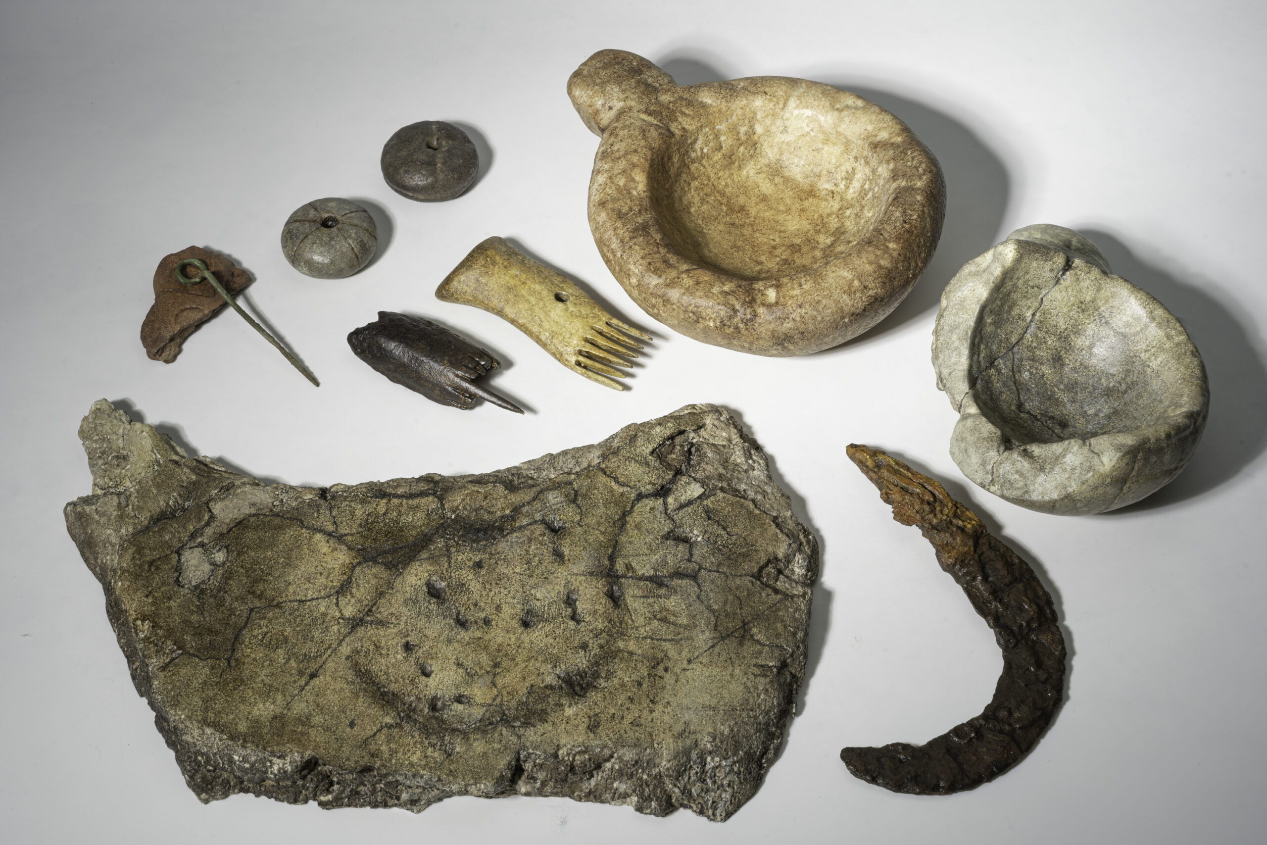
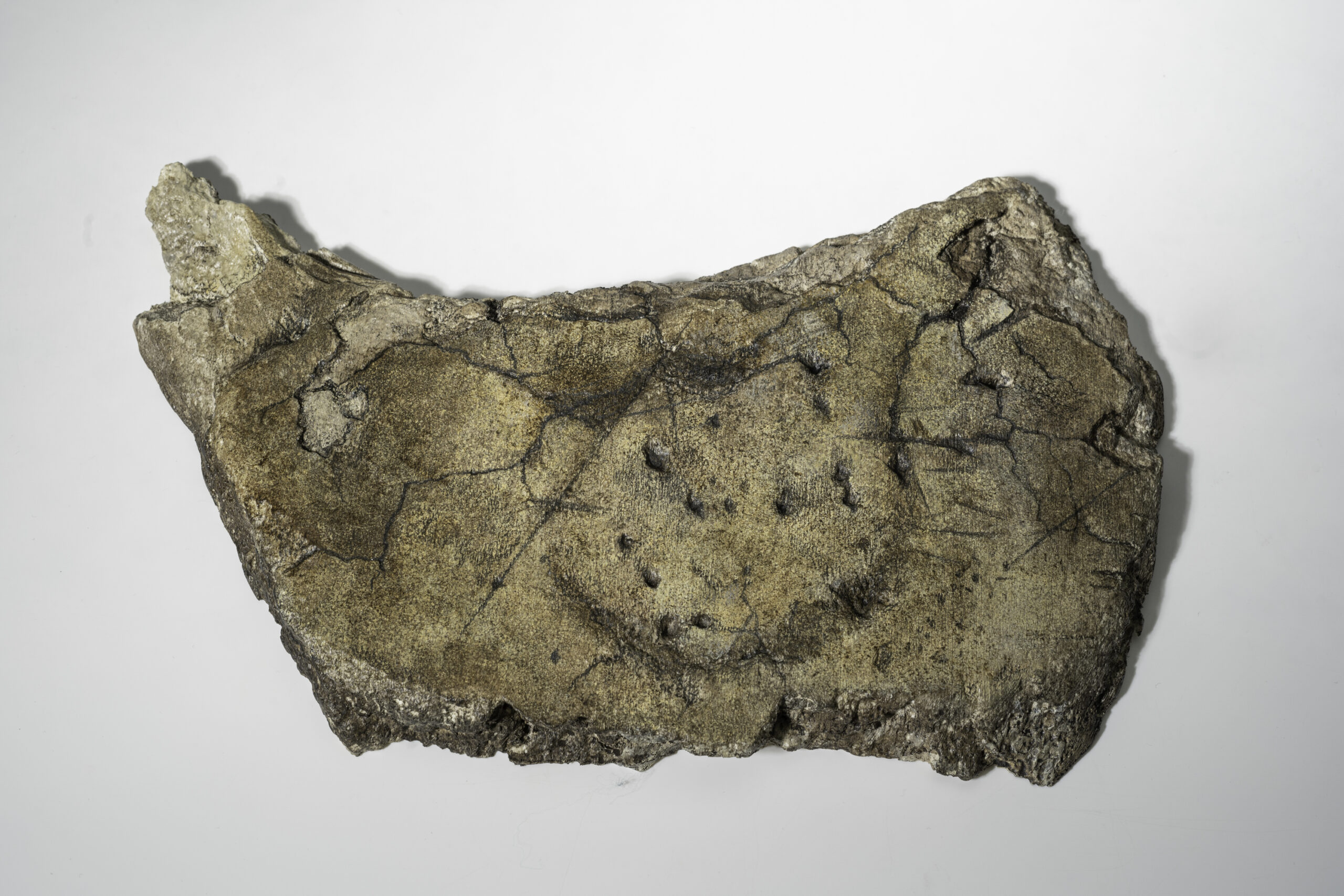
A range of objects – from pottery and stone to bone, were selected for high-resolution 3D recording. Using photogrammetry, we were able to create digital replicas of objects excavated at Clachtoll Broch.
Explore the interactive image of the broch to see the artefacts based on where they were found, or head to the bottom of the page to view the 3D gallery.
Digital recording has been used in archaeology for a while, but with development in technology, possibilities for augmenting archaeological processes with digital tools have advanced. Finds specialists and conservators can now analyse high-accuracy 3D models and use this digital record as a non-invasive method facilitating understanding of artefacts’ condition and their past. Interactive 3D models can be published online, and with a layer of storytelling, used for outreach purposes.
A new area that AOC is exploring is 3D printing: the tactile appeal of a 3D printed artefact can enable visitors to develop a more personal connection with places and history – they are experiencing the past through artefacts which they wouldn’t be able to touch otherwise. Another side of 3D printing technology, especially in recent years, is making heritage more inclusive and accessible for people with visual impairments:
dedicated handling kits are gaining more popularity across cultural institutions in the UK and beyond!
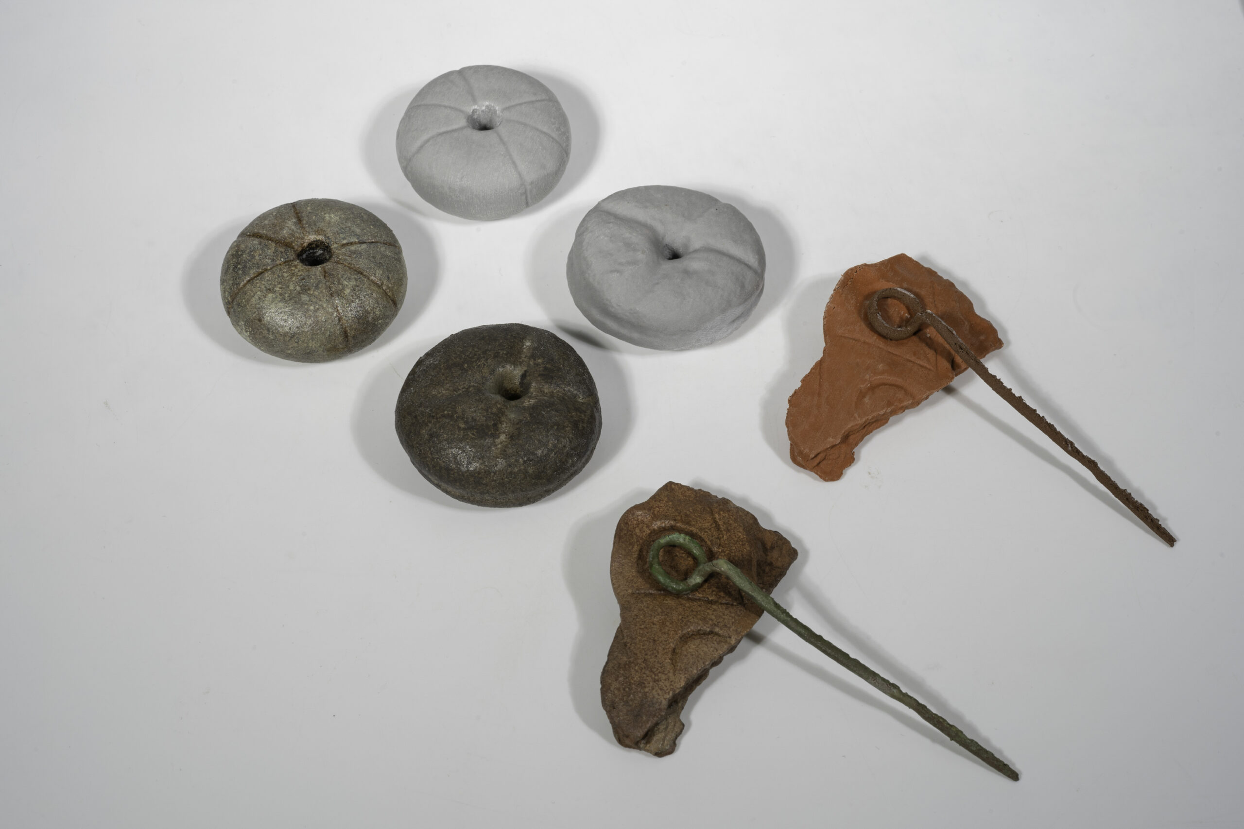
Working with Barclays Eagle Labs at CodeBase in Edinburgh, we printed several artefacts. Ana Aranda (Eagle Labs Engineer in Edinburgh) advised our team on the best materials for this purpose. We decided to use biodegradable Polylactic Acid (PLA) filaments infused with stone, metal or ceramic powder. These composites are heavier than standard PLA, providing a more tactile feel while handling. The ‘raw’ 3D prints were then finished and painted by hand, to imitate the look of the original artefacts.
The results, along with images of the Iron Age objects and photographs taken during the printing process, are presented in the gallery below:
A photography-based 3D recording method using 2D images to extract 3D information. This is done by reading perspective variations and differences in lines of sight in multiple overlapping images.
Its adaptability, scalability and potential to create highly accurate 3D outputs, regardless of the size of the subject recorded, made photogrammetry a widely popular 3D recording technique.
Used in the heritage sector in a broad spectrum of applications: from creating a detailed record of archaeological sites and buildings to conservation monitoring and long-term preservation of fragile museum collections.
Laser Scanning
Terrestrial laser scanning is one of the primary techniques that enable the rapid and highly-accurate acquisition of 3D data.
The scanners measure the 3D geometry by sending a laser beam to the surface of the recorded structure. The beam hits the surface and returns to the scanner – based on those two events the scanners can calculate distances and angles, assigning each measured point a precise location in 3D space.
Capturing millions of measurements per second, laser scanning became one of the primary tools used in surveying due to its speed and ability to produce high-resolution data. Laser scanned point clouds can provide valuable metric data, giving cross sections through buildings, or accurate terrain models of slight topographic features. 3D data can be processed into highly accurate CAD models for visualisation, or used to extract detailed 2D elevations and plans.
Reflectance Transformation Imaging (RTI)
Reflectance Transformation Imaging ( RTI) balances between 2D and 3D imaging. Whilst it captures 2D images, it allows for the object recorded to be digitally re-lit, creating an illusion of 3D surface. RTI dataset is created by capturing a series of images from a fixed camera position with the artefact illuminated by a light source incrementally moved around on a hemispherical grid. It records the subject’s shape and colour and is particularly useful for enhancing fine surface detail invisible under regular illumination.
3D printing
Archaeological artefacts can provide a tangible link to people who lived centuries, or even millennia, before us. However, most are too fragile to be handled freely and are viewed behind glass or stored in archives. 3D prints of artefacts, made from highly accurate 3D models created from data gathered through digital recording methods, can provide an opportunity for a tactile experience, allowing a more personal connection. 3D printing technology is also making heritage more inclusive and accessible for people with visual impairments – dedicated handling kits are gaining more popularity across cultural institutions in the UK and beyond.
3D Reconstructions
Digital reconstructions allow us to visualise lost archaeological sites or piece together fragmented artefacts recovered during excavations. Particularly useful in the analysis and interpretation of fragile archaeological finds, 3D reconstructions allow specialists to examine objects in a non-invasive way and experiment with innovative methods of communicating the results of these analyses.
Based on photos, archival maps, LiDAR data or 3D scans, digital models of cultural assets can be created and experienced in the virtual world by the viewer. Those reconstructions provide a way for audiences to explore artefacts from afar and present a fascinating new opportunity for engagement with the past.
LIDAR analysis
LiDAR (Light Detection and Ranging) is a remote sensing technique, used for high-resolution survey of landscapes.
The technology is based on the use of a laser scanner, mounted on an aircraft. Laser scanners emit pulses of laser light at a rate of many hundreds of pulses per second,
and measure the time it takes for the reflection of that pulse to return to the instrument; a GPS is used to plot the coordinates of each measurement. Using this method, computers are able to process millions of measurements in a dataset called a ‘point cloud’. In turn, this point cloud is then used to make very detailed presentations of the ground surface, called ‘digital terrain models’, often referred to as ‘DTMs’.
UAV Survey
Drones in the heritage sector are used as a low-level aerial method of recording archaeological sites, historic buildings, tall monuments, and landscapes. Equipped with high-resolution cameras, drones can access high-level structures to facilitate the inspection of historic sites. Accurate 3D records are generated from gathered images and used for survey, conservation, and maintenance work.
360⁰ Virtual Tours
Immersive way of making remote heritage sites more accessible. By taking a series of 360⁰ images, or spherical panoramas, we can create virtual tours of archaeological sites and historic buildings.