Since 2006, UHI Archaeology Institute has been carrying out archaeological excavations at The Cairnson South Ronaldsay, Orkney. Part of a wider archaeological research project investigating the later prehistory of the landscape around Windwick, their work now focuses on the substantial Iron Age broch and its surrounding settlement.
In 2018, work at the broch uncovered an astonishing Iron Age survival: a wooden bowl, preserved in waterlogged conditions within a two-metre-deep, rock-cut, subterranean structure, complete with a flight of stone stairs. These structures are usually described as wells, though their function is not clear.
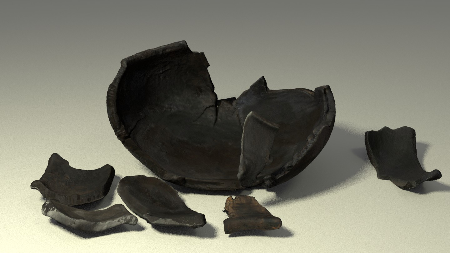
Wooden artefacts rarely survive in archaeological contexts, so the significance of the bowl was recognised from the outset. It was block-lifted, meaning that it was excavated within a block of the archaeological deposits that surrounded it, ensuring that it was supported throughout its removal from the ground. The block was transported to the conservation lab, where it was micro-excavated. It then underwent a range of specialist analyses to discover more about the bowl, its construction and its use.
Lab Excavation
The bowl was carefully micro-excavated by AOC’s conservators under lab conditions: the soil was removed and the bowl fragments recorded as they were lifted from the block. This helps in reconstructing the original form of the bowl, since we know the exact position of each fragment. It also allows any associated finds to be identified and recorded.
Micro-excavation in the lab
A scar from the handle reveled during conservation work
Conservation of the bowl
Waterlogged wood artefacts require careful conservation to ensure their long-term survival following removal from the ground.
After micro-excavation, each fragment of the bowl was gently washed from soil residue revealing smooth burnished interior, tool marks on the interior surfaces and a scar where a handle once protruded.
The next conservation steps include consolidation in polyethylene glycol (PEG), followed by vacuum freezedrying.
A Finely Made Possession
Despite being broken into many pieces, around 90% of the bowl survives. Analysis has revealed that the bowl was made from an alder log, finely carved, with a very smooth finish on the outside. It was probably burnished, possibly with sand or shavings, to give a polished appearance.
The interior is covered in short grooves, traces of the carver’s tools as they hollowed out the vessel. The grooves change direction, showing where the carver repositioned the bowl during work.
Dry reconstruction revealed the completeness of the bowl
3D-printed replica of the bowl
Digital Recording
Each of the fragments of the bowl got recorded using phtotorammetry. This resulted in an accurate 3D record, allowing us to create a digital reconstruction of the bowl, giving the specialist a complete view of the aferact, before conservation works were completed.
The 3D data was then used by Orkney 3D to create a physical replica of the bowl .
Reduce, Reuse, Recycle
The bowl from The Cairns has evidence of numerous repairs, suggesting it was much used and much loved.
Evidence of ancient repairs were found during conservation works. It was difficult to assess the extent of previous repairs with the naked eye, so the bowl was X-rayed which revealed multiple copper alloy zig-zag rivets, a large staple, and a rim mount. This allowed to locate the joints between the bowl’s loose fragments.
These numerous repairs leave no doubt that the bowl was a prized possession, considered worthy of mending to prolong its useful life.
X-ray of the bowl showing wavy rivets and the staple
Residue on one of the bowl sherds
Deposits and Residue Analysis
The soil deposits lifted along with the vessel were carefully wet sieved, allowing for retrieval of any other artefacts or ecofacts contained with the block.
AOC analysed the material, identifying burdock, bracken, heather, mosses and common chickweed as well as leaf, wood and bark fragments, helping paint a picture of the landscape of The Cairns at the time the bowl was deposited. The bowl itself contained brushwood, though it isn’t clear whether this was within the bowl when it was deposited in the well, or whether it made its way in later on.
Analysis of residues around the rivets identified animal fats including likely tallow (rendered animal fat often used in candles/lamps).
The residue in the base of the bowl may represent a dairy product – perhaps milk, butter or cheese from cattle, sheep or goat. Perhaps the bowl was used to process, store or serve dairy products.
A photography-based 3D recording method using 2D images to extract 3D information. This is done by reading perspective variations and differences in lines of sight in multiple overlapping images.
Its adaptability, scalability and potential to create highly accurate 3D outputs, regardless of the size of the subject recorded, made photogrammetry a widely popular 3D recording technique.
Used in the heritage sector in a broad spectrum of applications: from creating a detailed record of archaeological sites and buildings to conservation monitoring and long-term preservation of fragile museum collections.
Laser Scanning
Terrestrial laser scanning is one of the primary techniques that enable the rapid and highly-accurate acquisition of 3D data.
The scanners measure the 3D geometry by sending a laser beam to the surface of the recorded structure. The beam hits the surface and returns to the scanner – based on those two events the scanners can calculate distances and angles, assigning each measured point a precise location in 3D space.
Capturing millions of measurements per second, laser scanning became one of the primary tools used in surveying due to its speed and ability to produce high-resolution data. Laser scanned point clouds can provide valuable metric data, giving cross sections through buildings, or accurate terrain models of slight topographic features. 3D data can be processed into highly accurate CAD models for visualisation, or used to extract detailed 2D elevations and plans.
Reflectance Transformation Imaging (RTI)
Reflectance Transformation Imaging ( RTI) balances between 2D and 3D imaging. Whilst it captures 2D images, it allows for the object recorded to be digitally re-lit, creating an illusion of 3D surface. RTI dataset is created by capturing a series of images from a fixed camera position with the artefact illuminated by a light source incrementally moved around on a hemispherical grid. It records the subject’s shape and colour and is particularly useful for enhancing fine surface detail invisible under regular illumination.
3D printing
Archaeological artefacts can provide a tangible link to people who lived centuries, or even millennia, before us. However, most are too fragile to be handled freely and are viewed behind glass or stored in archives. 3D prints of artefacts, made from highly accurate 3D models created from data gathered through digital recording methods, can provide an opportunity for a tactile experience, allowing a more personal connection. 3D printing technology is also making heritage more inclusive and accessible for people with visual impairments – dedicated handling kits are gaining more popularity across cultural institutions in the UK and beyond.
3D Reconstructions
Digital reconstructions allow us to visualise lost archaeological sites or piece together fragmented artefacts recovered during excavations. Particularly useful in the analysis and interpretation of fragile archaeological finds, 3D reconstructions allow specialists to examine objects in a non-invasive way and experiment with innovative methods of communicating the results of these analyses.
Based on photos, archival maps, LiDAR data or 3D scans, digital models of cultural assets can be created and experienced in the virtual world by the viewer. Those reconstructions provide a way for audiences to explore artefacts from afar and present a fascinating new opportunity for engagement with the past.
LIDAR analysis
LiDAR (Light Detection and Ranging) is a remote sensing technique, used for high-resolution survey of landscapes.
The technology is based on the use of a laser scanner, mounted on an aircraft. Laser scanners emit pulses of laser light at a rate of many hundreds of pulses per second,
and measure the time it takes for the reflection of that pulse to return to the instrument; a GPS is used to plot the coordinates of each measurement. Using this method, computers are able to process millions of measurements in a dataset called a ‘point cloud’. In turn, this point cloud is then used to make very detailed presentations of the ground surface, called ‘digital terrain models’, often referred to as ‘DTMs’.
UAV Survey
Drones in the heritage sector are used as a low-level aerial method of recording archaeological sites, historic buildings, tall monuments, and landscapes. Equipped with high-resolution cameras, drones can access high-level structures to facilitate the inspection of historic sites. Accurate 3D records are generated from gathered images and used for survey, conservation, and maintenance work.
360⁰ Virtual Tours
Immersive way of making remote heritage sites more accessible. By taking a series of 360⁰ images, or spherical panoramas, we can create virtual tours of archaeological sites and historic buildings.